| NOTICE: This is NOT the directions to EVERY regatta we have. This is just the directions to these locations where we meet sometimes. Our monthly regattas are held at different locations and we always let those wanting to attend know exactly where and when we will be meeting. Below gives you a clear example of how directions will be sent to you. | |||||
 |
Hello Swinging Boaters!
 Below is your map to Temptation Island.
Be sure to read the entire page because there is more information at the
bottom. Below is your map to Temptation Island.
Be sure to read the entire page because there is more information at the
bottom.There are several photos below with very clear explanations so it will be very easy for you to find your way to our location. |
||||
|
Here is a brand new update that's pretty exciting! We
all know there is a huge satellite in outer space that takes photos of the
entire world. The photos shown below are the ones taken from this
satellite and that we downloaded off of Google. Well Google updates
their photos every few years with newer satellite photos and it just so
happens that the outer space satellite happened to be taking a photo of
Temptation Island during one of our regattas! It was a small regatta
because it was taken during the colder winter month of November and on
Sunday so there were only 5 boats left when the photo was taken, but you
can very clearly see our boats and when you zoom in, you'll see our boat
in the middle with the kayak on our bimini top!
Also... Some new technology from a
new company places all the marine navigational buoys and markers
throughout the Intercostal waterway as an overlay over the satellite
photos. It's really super cool! Just
click this link and Zooooom right on down to Temptation Island: Also... To those of you that have the 3-D software "Google Earth" installed on your computer, after clicking the link above, there is a button that says "View Chart in Google Earth" in the upper right corner of your screen, which will launch your Google Earth software and locate Temptation Island on it for you, in 3-D complete with all the navigational buoys and markers. This is super cool! Try it out!
|
|||||
|
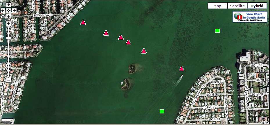
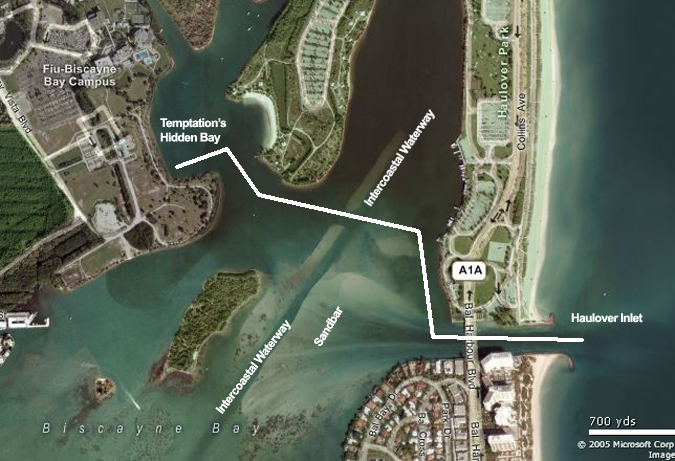
Photo Number 1: This shows 4 different landmark
locations to help you get your bearings.
1. Temptation Island
2. Windy Alternate Location 3. Haulover Inlet -
4. Haulover Marina
5. Windy Alternate Location 6. Windy Alternate Location |
|||||
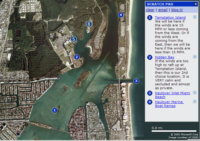 #1 - Temptation Island - This is our primary 1st Choice for the raft up depending on the weather. #2 - Hidden Bay - This is our back-up location for the raft up if the weather is rough. #3 - Haulover Inlet - This gives you a landmark for those arriving from the ocean. #4 - Haulover Marina - If you are trailering your boat, then this is where you will put it in the water. #5 - Oleeta West Fork - This is back-up location if there is going to be a strong or cold north wind #6 - Oleeta East Fork - This is back-up location if there is going to be a strong or cold north wind As you can see, everything is very close to each other. It's only 2 miles from Haulover Marina (#4) to Temptation Island (#1) and those are the the two farthest points from each other. There is plenty of deep water, but those coming in from the ocean with sailboats or yachts drawing a lot of water, be sure to take the channel to the north or south when you come in the inlet and don't cut straight across the sandbar or you might be staying there for your own raft up party. <smile>. |
|||||
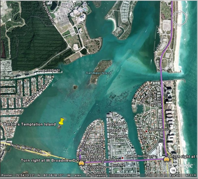
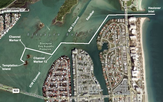 Following The White Line Above: GPS: N 25 degrees 53.536 - W 080 degrees 08.576 Coming in from the ocean through the Haulover Inlet, take the channel along the shoreline to the South past all the nice homes, working your way West to the Intercoastal Waterway (ICW). (You can also take the North channel to the ICW which has the deepest water but it takes a little longer) Once you're in the ICW, go South the the first marker which is "Marker 12" and look to the West and you'll see several red channel markers. Go West until you pass "Marker 6" then go South, (left) until you're right in front of the beach at Temptation Island, then go East to the raft up regatta party. Of course if you're not coming in from the ocean, then just find channel Marker 12 just South of the Haulover Inlet and then follow the rest of the directions above. |
|||||
|
|||||
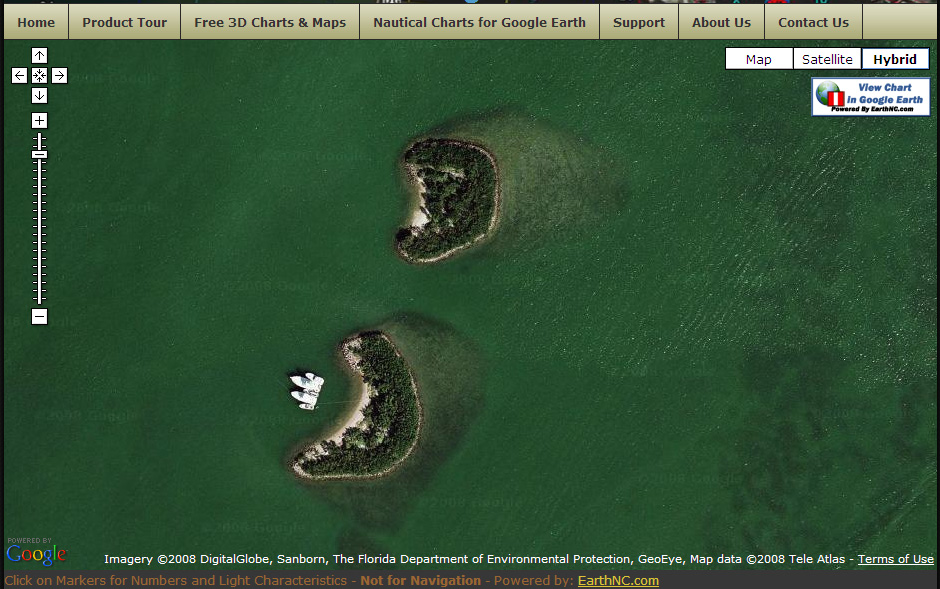
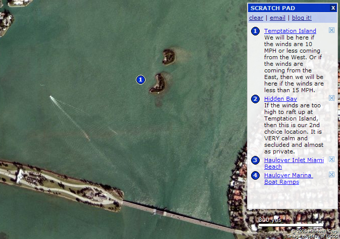 1. Temptation Island - This is a close up of Temptation Island. This is our preferred location for the raft up. If the winds are out of the west at less than 10 mph or out of the east at less than 15 mph then this will be where we will be meeting. There is lots of deep water but keep your eyes on your depth gauge whenever you leave the channel. This is the farthest island south and is the closest island to the Broad Street Bridge shown in the picture above. |
|||||
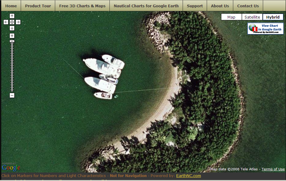
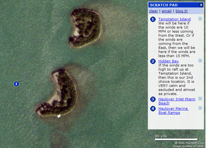 1. Temptation Island - This is what makes this island so special. It is surrounded by a barrier of rocks on the north, south and east sides with a nice sandy beach on the west side. This sandy beach is the ONLY place where you can get to the island. At low tide, the water is deep, 17' in most parts, and slowly rises 7'- 8' until you get about 10' from the beach. The bottom rises quickly about 10' from shore. The Haulover Inlet Tide Predictions are here, so sailboaters and large yachts should plan accordingly and arrive early if you think you need deeper water. Some super cautious sailboaters that want super deep water sometimes even anchor right outside the channel at Marker 6 and dingy over to our group so feel free to do that if you like. We just don't want anyone to be left out because they are nervous about any water depths. This makes it a great place to throw your anchor off your bow, let out lots of anchor line and back up to the island and then tie a line from your stern to the shore with your stern very close to the shore. This provides us with the ultimate in privacy. The beach is only about 150' long and we are expecting enough boats to raft up together taking up the entire beach which prevents anyone else from being able to see anything that's going on. We have our own private island with our own private beach protecting gawkers from seeing any of the activities going on outside our boats. It's perfect! |
|||||
 2. Hidden Bay - Here is a picture with exact directions of our back-up location. If the winds and seas are rough, then this is where we will be. If the winds are over 10 mph out of the west or over 15 mph out of the east, then this will be our meeting place. There is LOTS of deep water here but you really need to know where to find it. Coming in from Haulover Inlet, go North along the shorline until the shorline takes a turn inland. Then you will turn left and go West cutting across the Intercoastal Waterway, (ICW). There will be a couple signs that say, "shoal" and they mean it so don't hit the shoal. Keep an eye on your depth gauge being extra careful to stay in the channel that cuts between the two shoals as you head west. Once you get past there, then you're home free. Continue to the large opening into the bay, (there is a large zoomed up photo below) and when you look to the right you will see a little fishing pier and the nice white sandy beach, seen best in photo below. Go just past the pier and look to your left and in that little, private, secluded, tucked away corner of the bay, is our special place in this world that we like to call, Temptation's Hidden Bay, AKA "Party Cove". (Yes we know that nice white sandy beach would be a great place but as you'll see, it is a park that is filled with families so we stay far away from that about 1/4 mile to the west of them. |
|||||
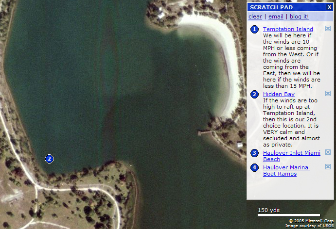 2. Hidden Bay - We've been here when the winds were over 30 mph with 45 mph gusts and very choppy seas in the intercostal and it was as calm as glass back in this corner with mostly privacy with only the occasional jogger or bike rider going along the bike path you see in the photo. This is our back-up location and will only be used if the weather is rough. Otherwise we will be at Temptation Island location #1. If all of that sounds confusing, then this makes it simple. Go to #1... if we're not there, Go to #2.
Don't Forget, YOU Are
Responsible For Knowing ALL Information On: |
|||||